

On March 1, 2025, a Venezuelan navy vessel entered Guyana’s exclusive economic zone (EEZ). It approached several assets, including the Prosperity floating production, storage and offloading vessel (FPSO) owned by ExxonMobil Guyana Limited.
Prosperity is one of several FPSOs operated by ExxonMobil Guyana as part of its joint venture with CNOOC Petroleum Guyana Limited (CPGL) and Hess Corporation in Guyana’s Stabroek Block under the 2016 PSA with the Government of Guyana. The joint venture also has several petroleum development projects in the Stabroek Block.
Guyana, the United Kingdom (UK), the United States of America, the Organisation of American States (OAS), the Caribbean Community (CARICOM), and others have condemned Venezuela’s conduct.
This was not Venezuela’s first incursion into Guyana’s EEZ. In 2013, the Venezuelan navy intercepted and detained the Teknik Perdana, a vessel carrying out seismic surveys in Guyana’s EEZ on behalf of Anadarko Petroleum Corporation. Again, in 2018, the Venezuelan navy intercepted vessels contracted by ExxonMobil Guyana to carry out surveys and attempted to land a helicopter on one.
Most pronouncements on Venezuela’s most recent conduct have emphasised its illegality under national and international law, arguing that the Prosperity FPSO and other assets were operating in Guyana’s EEZ when the Venezuelan navy intercepted them. Few explain the legal basis for these contentions of illegality.
In this article, I will outline and explain the legal basis underpinning Guyana’s delineated maritime zones. I will also attempt to demonstrate why the consensus is that Venezuela’s actions breach international law and Guyana’s national law.
However, before doing this, I will briefly summarise the history that gave the Essequibo, and consequently, the EEZ to Guyana.
The basis of Venezuela’s claim to Guyana’s EEZ
Venezuela’s claim to Guyana’s EEZ is rooted in its claim to the Essequibo. However, the Treaty of Washington (1897) between Great Britain and Venezuela resulted in the 1899 Award, which both parties agreed would be a full, perfect, and final settlement of all questions regarding the determination of the boundary between the territories.
The 1899 Award granted Venezuela the Orinoco River mouth and adjacent lands, and Great Britain (now Guyana) was awarded the lands East of the Essequibo River (Essequibo). An Anglo-Venezuelan Boundary Commission identified, demarcated, and fixed the boundary established under the 1899 Award. In 1905, the boundary was demarcated, and official boundary maps were produced.
For sixty-three (63) years (1899 and 1962), Venezuela accepted the legal validity of the 1899 Award and the boundaries it established. In 1963, for the first time, Venezuela said the Award was arbitrary and, therefore, null and void.
Again, these boundaries were the basis of Guyana’s delineation of its maritime zones, including its EEZ, where the Stabroek Block and ExxonMobil’s projects are located.
The parties signed the Geneva Agreement (1966) to attempt to resolve the controversy raised by Venezuela’s claim. After decades of efforts, no results were achieved, eventually prompting the United Nations Secretary-General to refer the issue to the International Court of Justice (ICJ), which is currently hearing the matter.
Sovereignty and maritime zones
In simple terms, sovereignty and sovereign control refer to the right of a state to control its affairs within a defined space without the interference of any other party, domestic or foreign. States exercise sovereign control over their land and the airspace above it. Coastal countries like Guyana also exercise certain sovereign rights in their maritime zones.
The United Nations Convention on the Law of the Sea (UNCLOS) acknowledges the existence of the following maritime zones offshore coastal states: the territorial sea, the contiguous zone, the exclusive economic zone (EEZ), and the continental shelf.
Notably, the language of UNCLOS does not appear to establish or create these zones. Instead, it seems to recognise and codify their existence. For example, Article 55 of UNCLOS states that “the [EEZ] is an area beyond and adjacent to the territorial sea…” Article 76 (1) of UNCLOS states that “the continental shelf… comprises the seabed and subsoil of the submarine areas that extend beyond its territorial sea throughout the natural prolongation of its land territory…”
This language is intentional, recognising the general state practice or custom which eventually resulted in the codification of these maritime zones in UNCLOS.
Under UNCLOS: the territorial sea extends 12 nautical miles (nm) from a state’s baseline (Article 12 of UNCLOS); the contiguous zone extends 24 nm from the baseline (Article 33 of UNCLOS); the EEZ extends 200 nm from the baseline (Article 57 of UNCLOS); and the continental shelf extends the length and breadth of the natural prolongation of a State’s land territory to the outer edge of the continental margin, or to a distance of 200 nm from the baseline from which the breadth of the territorial sea is measured where the outer edge of the continental margin does not extend to that distance (Article 75 (1).
These maritime zones, including their breadths, were incorporated into Guyana’s Maritime Zones Act, Cap 63:01, Laws of Guyana (MZA), which also recognises Guyana’s territorial sea (section 3), its contiguous zone (section 17), its EEZ (section 26), and its continental shelf (section 20).
Where in Guyana’s EEZ is the Prosperity FPSO located?
According to the Environmental Impact Assessment (EIA) for the Payara Project, the Prosperity FPSO is located approximately 114 nm from Guyana’s baseline.
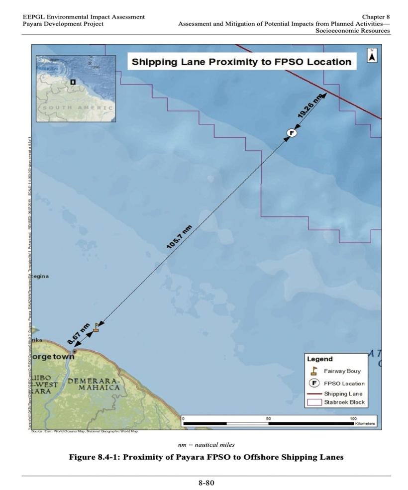
Image from EEPGL Environmental Impact Assessment for the Payara Development Project
This puts the FPSO within Guyana’s 200 nm EEZ. The Payara Development Project, near the Prosperity FPSO, is also within the country’s continental shelf, with the wells on Guyana’s continental shelf.

According to the EIA for the Payara Project, the Project is located 207 km (approximately 111 nm) offshore Guyana. Again, this would put the Payara Project within the areas delineated by Guyana as its EEZ and continental shelf.
Guyana’s Sovereign Rights in its EEZ and Contiguous Zone
Under UNCLOS and the MZA, Guyana has the “sovereign right” to explore and exploit the resources of the seabed and its subsoil below its EEZ (Article 56 (1) of UNCLOS and section 27 (a) of the MZA. Guyana also has the exclusive sovereign right to explore and exploit the natural resources of its continental shelf (Article 77 (1) and (2) of UNCLOS, and section 21 (1) (a) of the MZA. Further, Guyana has the “exclusive right” to authorise and regulate drilling on its continental shelf for all purposes (Article 81 of UNCLOS).
Together, these provisions give Guyana the exclusive sovereign right to, itself, or through any other party, explore and exploit the seabed and the subsoil (where the petroleum is found), to explore and exploit its delineated continental shelf (on which the seabed and subsoil lie), and to regulate any drilling it authorises on its continental shelf.
As such, when the Venezuelan naval vessel informed Prosperity that it was operating in disputed international waters and approached other vessels/assets operating in the area delineated by Guyana as its EEZ, these actions violated the above-mentioned Articles of the UNCLOS and sections of the MZA. Put differently, Venezuela’s conduct violated international law (UNCLOS) and Guyana’s national law (the MZA). The conduct is also characterised as violating Guyana’s sovereignty (and a further breach of international law) because it interfered with Guyana’s right to control its affairs within its maritime boundaries without external interference.
It is true that all states, including Venezuela, have freedom of navigation through the EEZ of a coastal state (see Article 58 (1) of UNCLOS). Though this provision has not been expressly incorporated into Guyana’s laws, it still applies because Guyana has declared that it will have due regard to the rights and duties of any other State in its EEZ and shall act according to international law (section 31 of the MZA).
However, in exercising this freedom of navigation, the navigating state must have due regard to the coastal state’s rights in its EEZ, not unduly interfere with the exercise of those rights, and comply with the laws of the coastal state (see Article 56 (2) and 58 (3) of UNCLOS).
Given the foregoing, the Venezuelan vessel’s actions (interfering with Prosperity and other assets) are not viewed as exercising freedom of navigation, not least because the vessel’s sole purpose seemed to be to (and it did, even if momentarily) interfere with Guyana’s right to explore and exploit the carbon resources in the seabed below its delineated EEZ/continental shelf.
The conclusion that flows from these legal and factual realities is that Venezuela has violated international law and breached Guyana’s national law.
The 1899 Arbitral Award stands as valid unless the ICJ finds otherwise. The boundaries fixed by the Arbitral Award, which gave the Essequibo to Guyana, still stand. Venezuela’s unilateral rejection of the Award and the established boundaries could not and did not vitiate either. Therefore, there is currently no valid basis, legal or otherwise, on which Venezuela can claim the area where the Stabroek Block is located, primarily since that claim is based on its illegal claim to Essequibo.
This position is supported, in part, by the ICJ, which has observed that: “The situation that currently prevails in the territory in dispute is that Guyana administers and exercises control over that area. The Court considers that pending the final decision in the case, Venezuela must refrain from taking any action which would modify the situation.”
The ongoing ICJ proceedings
In 2020, the ICJ found that it had jurisdiction to hear the case filed by Guyana to affirm the 1899 Award. In 2023, following conduct by Venezuela intended to interfere with Guyana’s control of the Essequibo, the ICJ granted provisional measures against Venezuela, ordering it to refrain from taking any action that would affect Guyana’s administrative control over the area (Essequibo).
There is a view that the March 1 incident violates the preliminary measure, but this is unclear.
In its decision on jurisdiction, the ICJ limited its jurisdiction to considering the validity of the 1899 Award and settling the land boundary dispute between Guyana and Venezuela. The ICJ also said that it does not have jurisdiction to entertain claims arising after the signature of the Geneva Agreement.
It is unclear whether the ICJ can address this recent incident as part of the land boundary dispute. However, this question could be resolved if Guyana approaches the ICJ to claim that Venezuela’s recent conduct has breached the 2023 provisional measures.
In any case, these are the historical realities, international and national law, and court-issued preliminary measures which found the assertions that Venezuela’s conduct on March 1 breached international and national law.